12 Aug 2023: China launched the world’s first GEO based Synthetic Aperture Radar (SAR) imaging satellite (Ludi Tance-4-01 <LDTC-4-01> or LSAR4-01) on a Long March 3B rocket from Xichang. The LDTC-4-01 gives China a permanent view of nearly one-third of the Earth’s surface, and provides “all-day, all-weather observation of China and surrounding areas.” The series is separate from the China High-resolution Earth Observation System (CHEOS), which consists of Gaofen (“high resolution”) satellites. SAR at GEO, while providing much lower resolution than satellites in low Earth orbit, offers advantages such as a short observation revisit periods and wide imaging width. Launch Video1 and Video2. Watch mission rendition Video.
– On or about 23 August, Ludi Tance (translates as Land Exploration)-4-01 circularized its orbit and is now in geostationary orbit at 89.6° East longitude with an inclination of 16.1°.
– The (01) designation suggests China could launch other SAR satellites into GEO.
-On 21 Aug Chinese news sources announced LDTC-4-01 entered its operational orbit, that the satellite was in sound condition with the SAR antenna successfully deployed, and will carry out in-orbit testing as a follow-up task.
-LDTC-4-01 entered the preset orbit after four orbital maneuvers, said Meng Lingjie, deputy chief designer of engineering at CNSA’s Earth Observation System and Data Center. Meng said unfurling the large circular SAR antenna was “very critical,” as only after that can meticulous in-orbit testing be carried out. He further stated China will put the satellite into service after fully completing in-orbit testing.
– LDTC-4-01 is in line with China’s 2015-2025 medium and long-term development plan for civilian space infrastructure, which lists the Ludi Tance satellite series and high-orbit SAR technology.
– In early 2022, China sent a pair of Ludi Tance 1-01 satellites to LEO (~600 km). Each weighed about 3.2 tons and was equipped with an advanced SAR payload, for a total antenna area of 33 square metres (355 sq ft), and operating in the L-band.
– China Aerospace Science and Technology Corporation (CASC) developed LDTC-4-01 and stated the satellite also worked in the L-band. CASC’s “blue book” outlining plans for 2023, released in January, noted the launch of a “high-orbit 20-meter [resolution] SAR satellite.”
– CASC has released few details about the satellite’s configuration. Stephen Hobbs, space systems and sensors professor from England’s Cranfield University, said the device was likely to have a 20 meter-wide circular, deployable antenna — much larger than those used on Ludi Tance 1-01A and 1-01B.
– Hobbs said LDTC-4-01 might also be equipped with 10-20 square meters of solar arrays to generate several kilowatts, as radar satellites usually require higher electrical power levels. He also noted the satellite’s 20 meter spatial resolution “is actually quite good for geosynchronous radar.”
– A major challenge in developing geosynchronous SAR satellites is the long range, which results in weak signals. Hobbs said high transmitter power, large antennas, and relatively long signal integration times were needed to compensate for this.
LDTC-4-01 is located West of China’s other Geostationary based imagery satellites, Gaofen-4, Gaofen-13-01, and Gaofen-13-02. Having a GEO base SAR capability allows for all weather monitoring of large areas (think South Pacific and Taiwan Straights) and the ability to cross-cue with other platforms (LEO or airborne) with higher resolution sensors, for positive identification (PID).

Geostationary locations of LDTC-4-01, Gaofen-4, Gaofen-13-01, and Gaofen-13-02.

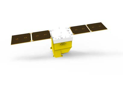
Artist rendering of the LDTC-4-01 geosynchronous synthetic aperture radar satellite.

LDTC-4-01 mission patch.