1 Mar 2022: Ukraine is openly seeking the cooperation of commercial satellite operators. The goal is to obtain data, particularly from synthetic aperture radar, about the movement of Russian vehicles so that Ukrainian forces can respond.
– Mykhailo Fedorov, the Vice Prime Minister and Minister of Digital Transformation of Ukraine stated: “We badly need the opportunity to watch the movement of Russian troops, especially at night when our technologies are blind in fact! SAR satellite data is important to understanding Russian troop and vehicles movements at night considering that clouds cover about 80 percent of Ukraine during the day”
– EOS Data Analytics (a company founded by Ukrainian Max Polyakov) offered to quickly analyze and process data for use by the Ukrainian Defense Service. The company has set up a webpage here with more information.
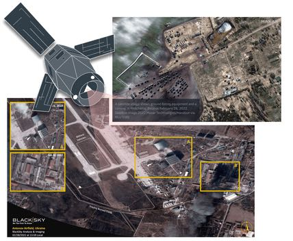
– Commercial companies have been releasing high-resolution satellite imagery into the public domain to showcase their capabilities. While this has been impressive, such releases have been more useful for public relations purposes than for giving actionable information to the Ukrainian military. The data is often two or three days old.
– Polyakov appealed to Planet Labs, Maxar Technologies, Airbus, SI Imaging Services, SpaceView, BlackSky, Iceye, Capella, and other companies to provide the needed data.
– Capella Space turned down the Polyakov-initiated request, saying, “We do not work with individuals or entities restricted or sanctioned under United States government export laws and regulations.”
– Capella Space did state that they are “working directly with the US and Ukrainian governments as well as other commercial entities to provide timely data and assistance around the ongoing conflict”
Read excellent review of Open Source (including Space) Intelligence in the Ukrainian conflict.
This is the first major war in which commercially available satellite imagery has played a significant role in providing open source information about troop movements, military buildups in neighboring countries, flows of refugees, and more.
The role of such a powerful, widely available technology has yet to be defined in a warfighting domain, and it’s not clear whether private companies are willing to freely hand over raw data to another commercial company with the intent of helping one side in the conflict.

Battle-damage assessment using Planet satellite imagery.

Maxar satellite image of Russian military buildup.
Capella Space imagery of Russian forces arriving in Crimea.