

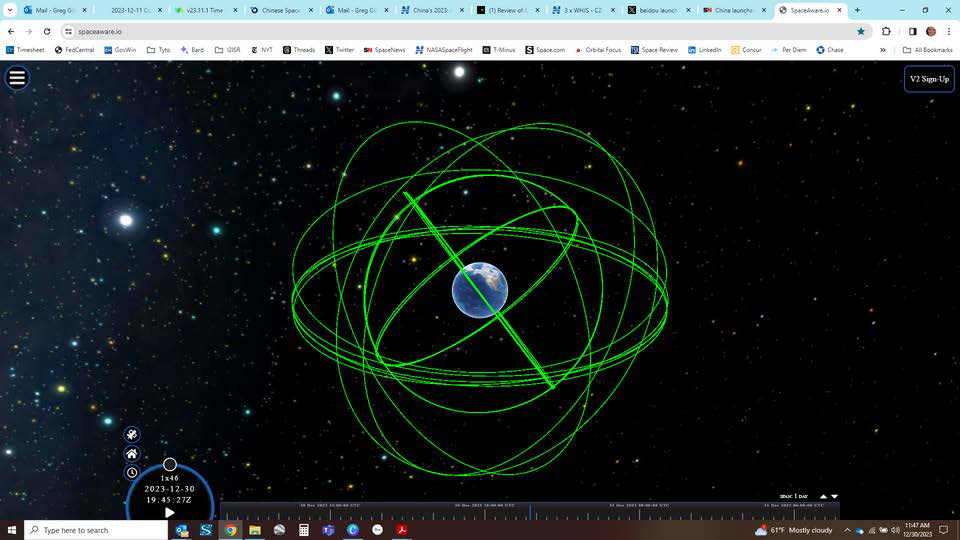



26 Dec: China launched a Long March-3B with a Yuanzheng-1 upper stage from Xichang with two backup BeiDou-3 navigation satellites (BeiDou-3 MEO-25 & MEO-26). Both satellites were sent to medium earth orbit (MEO) and are the 57th and 58th of the BeiDou family and the second and the third to act as a backup satellites…
26 Dec: China launched a Long March-3B with a Yuanzheng-1 upper stage from Xichang with two backup BeiDou-3 navigation satellites (BeiDou-3 MEO-25 & MEO-26). Both satellites were sent to medium earth orbit (MEO) and are the 57th and 58th of the BeiDou family and the second and the third to act as a backup satellites. Launch Video. Booster inbound video…take cover!
– MEO-25 and -26 are in 21,532 x 22,193km orbits with an inclination of 55°.
– The satellites were developed by the China Academy of Space Technology (CAST) under CASC, the country’s main space contractor.
– Beidou is China’s own global navigation satellite system (GNSS) to rival the U.S. GPS, Europe’s Galileo and Russia’s GLONASS systems. China completed its construction in mid-2020.
-China embarked on building the BeiDou constellation in 1996 after it suspected 2 of its 3 missile tests over Taiwan failed due to their reliance on GPS.
– According to one PLA Colonel at the time: “It was a great shame for the PLA … an unforgettable humiliation.”
-In 1996, China decided to build its own navigation system, to be completed within 25 years, to establish truly independent military command and control, and precision missile guidance and tracking.
– The end result was the establishment of the independent GNSS and PNT systems, the PLA Strategic Support Force, and the development of China’s missile capabilities, to include cruise missiles, ballistic missiles, and hypersonic missiles under the PLA Rocket Force.
-Watch short Video on the history of BeiDou.
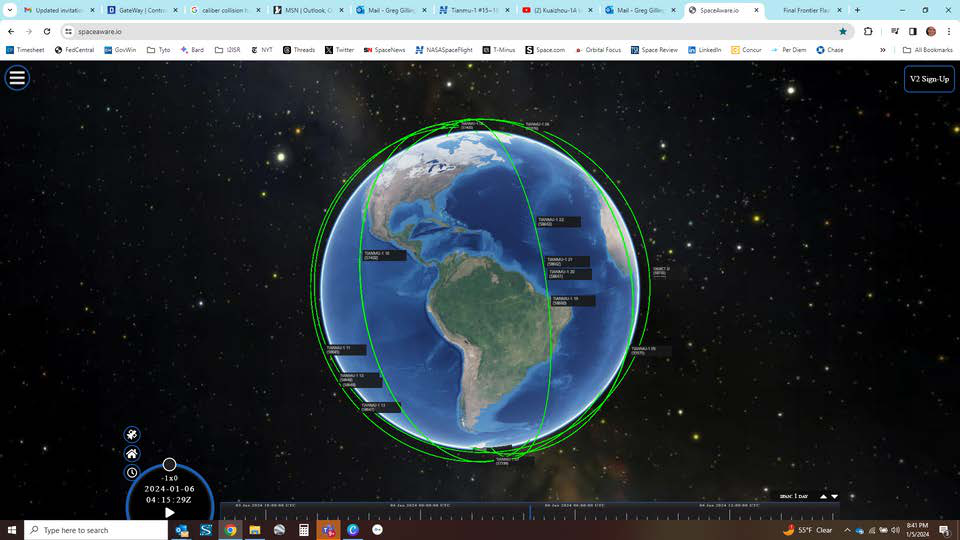
25/27 Dec 23 & 5 Jan 24: China launched 3 Kuaizhou-1A (KZ-1A) rockets from Jiuquan, each with four Tianmu-1 meteorological satellites. The first launch placed the Tianmu-1 11-14 satellites into orbit, the second carried Tianmu-1 19-22 and the third carried Tianmu-1 15-18 satellites. There are now 22 Tianmu satellites…
25/27 Dec 23 & 5 Jan 24: China launched 3 Kuaizhou-1A (KZ-1A) rockets from Jiuquan, each with four Tianmu-1 meteorological satellites. The first launch placed the Tianmu-1 11-14 satellites into orbit, the second carried Tianmu-1 19-22 and the third carried Tianmu-1 15-18 satellites. There are now 22 Tianmu satellites in Low Earth Orbit. Per official Chinese sources the Tianmu constellation “will be mainly used to provide commercial meteorological data services”. Launch 1 Video. Launch 2 Video. Launch 3 Video.
– All 12 new Tianmu-1 satellites are in a similar orbit with the other Tianmu satellites, 528x512km and 95.1° inclination.
-The Tianmu 1 constellation is intended to provide global commercial meteorological data services, including numerical weather forecasting, typhoon monitoring and forecasting, and climate change research.
-China launched all 14 Tainmu satellites in 2023.
– The final number of satellites for the Tianmu constellation is unknown. However, Gao Wei, strategic operations director of the Tianmu 1 constellation, told CCTV+ “By 2025, our Tianmu 1 system will be basically completed and will provide stable service for various user categories.”
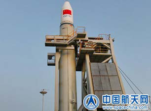
25 Dec: China launched a Long March-11 from a sea-based platform off the coast of Yangjiang, Guangdong Province, China. The rocket carried 3 Shiyan-24C satellites to Low Earth Orbit. According to official sources, the three Shiyan-24C satellites “will be mainly used for space science and technology experiments”. The…
25 Dec: China launched a Long March-11 from a sea-based platform off the coast of Yangjiang, Guangdong Province, China. The rocket carried 3 Shiyan-24C satellites to Low Earth Orbit. According to official sources, the three Shiyan-24C satellites “will be mainly used for space science and technology experiments”. The trio joins the Shiyan-24A/B satellites which China launched in June 2023. Launch Video.
– The three Shiyan-24C satellites are in a 541x544km orbit with a 95.6° inclination.
– The satellites are expected to contribute to a multitude of experiments, including those related to Earth observation and telecommunications. The satellites’ specific scientific objectives have not been publicly detailed.
–Shiyan 24A & 24B were launched on the 2nd CAS Space Kinetica-1 back in June, a launch where most of the payloads are still not identified.
– Interestingly, the SY-24 satellites are nearly co-planar with the SJ-6-05A/B satellites launched on 9 Dec 2021.
-In Feb 2022 Feb, analysis from LEO Labs indicated SJ-6 05A and 05B had setup for rendezvous and proximity operations (RPO).


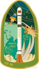
30 Dec: China continued to launch internet test demonstration satellites as it used a Long March-2C from Jiuquan. As with other internet demonstration launches there is confusion as to how many were actually on-board. While China announced the launch of a single “satellite,” the space catalog is tracking 3 objects…
30 Dec: China continued to launch internet test demonstration satellites as it used a Long March-2C from Jiuquan. As with other internet demonstration launches there is confusion as to how many were actually on-board. While China announced the launch of a single “satellite,” the space catalog is tracking 3 objects, only one of which is listed “active” and the other two as “unknown.” For what it’s worth, the launch patch has 3 stars. Launch Video.
– The Chinese named the satellite(s) Weixing Hulianwang Jishu Shiyan (WHJS) which translates to “Satellite Internet Technology Demonstration Satellite,” or something similar.
– The launch placed all three objects into a ~940x930km orbit with a 50° inclination.
– More observations are required to determine if all three objects are maneuvering/operational.
– This launch appears to be similar to another WHJS launch (2023-095) on 9 July 2023. There was initial confusion regarding the number of satellites on that mission as well, with China announcing a single satellite, but actually 2 maneuvering objects were on board. That launch patch has 2 stars.
– Both launches used a LM-2C with a YS-1 upper stage from Jiuquan. However, the 30 Dec launch (2023-212) resulted in the payloads being deployed to a lower altitude (SMA 934.5km vs 1,111.4km). The inclinations are also different 2023-212 at 50° compared to 86.5° for 2023-095.
– China conducted 5 Internet Test Demonstrator launches in the last 6 months of 2023:
1. 9 Jun 2023: Longjian-3 satellite from Jiuquan using a KZ-1A. (471.9km/49.1°)
2. 9 Jul 2023: 2 WHJS satellites from Jiuquan using a LM-2C with a YS-1 upper stage (1,111.3km/86.5°)
3. 23 Nov 2023: Chuangxing-20 01,02,03 from Xichang using a LM-2D with SY-3 upper stage (1,104.2km/50°)
4. 5 Dec 2023: Unknown satellite from Yellow Sea using a Jielong-3 (913.3km/86.5°)
5. 30 Dec 2023: 3 WHJS satellites from Jiuquan using a LM-2C with a YS-1 upper stage (936.4km/50°)



27 Dec: China's Yaogan-41 GEO-based imager has settled into geostationary orbit at 123.3°E longitude. This places the spacecraft, with rumored 5m imagery resolution , just east of Gaofen-13-01. Gaofen-13-1 and Yaogan-41 now bracket the island of Taiwan. Yaogan-41's orbit is inclined 5° while Gaofen-13-1 is only…
27 Dec: China’s Yaogan-41 GEO-based imager has settled into geostationary orbit at 123.3°E longitude. This places the spacecraft, with rumored 5m imagery resolution, just east of Gaofen-13-01. Gaofen-13-1 and Yaogan-41 now bracket the island of Taiwan. Yaogan-41’s orbit is inclined 5° while Gaofen-13-1 is only inclined 0.2°. Increasing the Yaogan-41’s inclination will periodically bring it closer to Taiwan and other targets, presumably resulting in better imagery resolution. Of course, the higher inclination also takes the satellite further south and negatively impact resolution as well. China launched YG-41 on 15 Dec 2023 using a LM-5 with an extended payload fairing. Launch Video.
– YG-41 is China’s 4th optical satellite in GEO. In addition to the previously mentioned Gaofen-13-1, YG-41 joins the civilian Gaofen-4 (2015) and Gaofen-13-2 (2023). China also recently added the world’s first SAR imaging satellite in GEO, Ludi Tance 4-01.
-Chinese scientists have briefed that Gaofen satellites designated 8 or higher are associated with military/national security missions. All Yaogan designated missions are believed to have military/national security missions.
– Gaofen-13-1 and 13-2 are believed to be capable of 15m resolution imagery.
– China may be experimenting with different inclination values for its GEO-based imagers. China has placed each successive satellite into a higher inclination…GF-4 at .1°, GF-13-1 at .2°, GF-13-2 at 2.4° and now YG-41 at 5°.
– All GEO imagers seem to be in orbits to provide constant surveillance of the Western Pacific and areas of potential conflict. GF-13-1 and YG-41 are located on either side of Taiwan and GF-13-02 is 2° East of Guam and <1° East of the Northern Marianas Islands.
– Ludi-Tance-4-01 is the world’s only GEO-based synthetic aperture radar (SAR) imager and located further west than any of the other GEO imaging satellites. It is also highly inclined at 15.9°, likely to provide the relative motion with the Earth’s surface to enable it’s expected 20m resolution. China classified Ludi-Tance-4 as a civilian satellite, it is unknown if the satellite is being used for military/national security missions.

11 Dec 2023: Kristin Burke of the China Aerospace Studies Institute released her paper exploring command and control of a variety of China's counterspace weapons. Ms Burke poses 2 questions to 6 types of counterspace weapons: 1) Who in the People's Liberation Army (PLA) will operate counterspace weapons in wartime? and…
11 Dec 2023: Kristin Burke of the China Aerospace Studies Institute released her paper exploring command and control of a variety of China’s counterspace weapons. Ms Burke poses 2 questions to 6 types of counterspace weapons: 1) Who in the People’s Liberation Army (PLA) will operate counterspace weapons in wartime? and 2) Who will task the operators and how will the operators use counterspace weapons in wartime? Interestingly her research indicates that likely not all counterspace weapons will be operated by the Strategic Support Force (SSF) with many remaining under the command of the Central Military Commission (CMC) or Theater Command (TC) commanders. Excerpts below. Read FULL REPORT for yourself!
– The six categories of counterspace weapons are: 1) Direct Ascent Anti-Satellite Missiles (DA ASAT); 2) Directed Energy Counterspace Weapons; 3) Terrestrially Based Satellite Electronic Jammers; 4) Space-based Grappling Counterspace Weapons; 5) Offensive Cyber Counterspace Weapons; and 6) Space Based Electronic Jammers.
– Limited experimental space-based counterspace weapons are probably operated exclusively by the SSF’s Space Systems Division (SSD).
– People’s Liberation Army (PLA) Theater Command (TC) commanders may have more ease in tasking low-powered directed energy counterspace weapons and some network-electromagnetic spectrum weapons than terrestrially-based satellite electronic jammers.
– It seems that while terrestrially-based satellite electronic jammers are prevalent across the TCs, the CMC must pre-approve specific usage, in order to limit spectrum interference within the People’s Liberation Army (PLA).
– Reversible satellite laser dazzling and weapons to disable systems using space information, such as microwave weapons and network-electromagnetic spectrum weapons, can probably be readily tasked at the TC level.
– There is limited publicly available information to support that the SSF is the service training with direct-ascent anti-satellite (DA-ASAT) missiles. Rather, there is more information to support those missiles may be operated by other PLA services.
– DA-ASAT missiles potentially could be deployed from many more places than expected, the PLA’s primary intention for the missiles is to be a credible deterrent, and only the CMC would cautiously approve their use…there is evidence to indicate that the SSF is not the exclusive owner of those <DA-ASAT> mobile launchers.
– CMC consent for usage of other types of counterspace weapons seems to depend on if the
weapons’ effects go beyond the theater of use.
– CMC probably directs cyberattacks on satellite ground stations in theater, especially attacks to deliver malware to adversary satellites, because of the beyond-theater effects.
– On-orbit satellite jamming is the one counterspace weapon this report found to be operated exclusively by the SSF.
– On-orbit grappling is unlikely to be used as a counterspace weapon until those systems can be miniaturized.
– The PLA seems to be modeling the United States in developing a dedicated unit to conduct defensive and offensive orbital warfare, like Space Force Delta 9, and orbital warfare exercises like Red Skies.
Wartime operation of the People’s Liberation Army’s (PLA’s) counterspace weapons highly likely continues to be spread across PLA services, as well as the Strategic Support Force (SSF)….not all counterspace weapons are managed by the SSF.
19 Dec: Chinese military scientists revealed a previously confidential space war-gaming system. According to the developers, the system features a user-friendly design and can simulate and predict the complex process of space combat. This Chinese space war simulator intended not only for the country's military…
19 Dec: Chinese military scientists revealed a previously confidential space war-gaming system. According to the developers, the system features a user-friendly design and can simulate and predict the complex process of space combat. This Chinese space war simulator intended not only for the country’s military operations but also for training and enhancing space commanders and warriors on a much more substantial scale. Watch Australian News Report.
– The National University of Defense Technology in Changsha developed the system, as per a paper published in National Defence Technology in October. The paper, authored by a team led by associate professor Zhang Jin, had a section stating that the system has already demonstrated its effectiveness in a secret space mission.
– Over 400 military cadets created over 70 teams in September for a rigorous, two-month competition. Many participating members claimed that these simulated space battles
prepared them for combat and offered them a first-hand experience of operating weapons that they had only studied in technical documents or textbooks.
-One of the system’s most prominent features is that it can make the Earth transparent in the operation interface, thus allowing users in the Eastern Hemisphere to view situations in the Western Hemisphere.
– The researchers also listed a number of challenges they encountered during the development of the space war-gaming system. War in space, they said, offered no real battles as examples. Despite cold war tensions and recent close calls between China and the US in orbit, no true fight has broken out.
– They also wrote of the struggle to secure weapon data. Space weapons are closely guarded secrets, and any misstep in this data could send military strategy astray.
– To ensure the system would run smoothly even in the most challenging moments of war, researchers considered computational complexity while making sure the calculations could be performed on a mobile military computer.
– To achieve this, the scientists employed parallel computing technologies typically used only in supercomputers, improving computational efficiency and enabling inferior military-grade CPUs to produce simulation results within a short time frame.
The Chinese military is actively developing a new generation of anti-satellite weapons, including high-power microwave emission devices and laser guns. Additionally, the Chinese government plans to launch nearly 13,000 low-Earth orbit internet satellites equipped with military payloads to establish a counter-deterrent against the US.

There were no shortage of “Year in Review” articles this month. Three in particular are worth your time: 1) Adrian Bell, NASA Space Flight, China's 2023: closing out a busy year amidst preparations for lunar missions ; 2) China Space Monitor, The Year in Chinese Space ; and 3) Andrew Jones, China Space Bulletin: Review…
There were no shortage of “Year in Review” articles this month. Three in particular are worth your time: 1) Adrian Bell, NASA Space Flight, China’s 2023: closing out a busy year amidst preparations for lunar missions; 2) China Space Monitor, The Year in Chinese Space; and 3) Andrew Jones, China Space Bulletin: Review of China space activities in 2023. Highlights below.
Adrian Bell: China’s 2023
China Space Monitor: The Year in Chinese Space
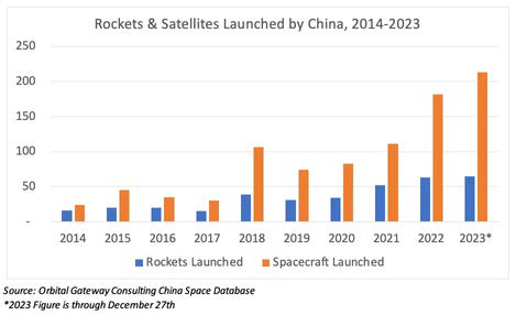
2023 saw the record for most satellites launched on a Chinese rocket broken twice in one month. First, on 7 June, CAS Space sent 26 satellites into orbit on its ZK-1A from Jiuquan.
Andrew Jones: Review of China Space Actitities in 2023
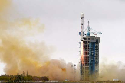

21 Dec: Russia launched a Soyuz-2-1b (also report of 2-1a) rocket lifted off from Plesetsk and successfully delivered a spacecraft for the Ministry of Defense. The spacecraft has since been renamed Kosmos-2573 and could be the latest of 5 Bars-M imagery satellites. Launch Video . - Kosmos-2573 (Bars-M N°5 ) is in a…
21 Dec: Russia launched a Soyuz-2-1b (also report of 2-1a) rocket lifted off from Plesetsk and successfully delivered a spacecraft for the Ministry of Defense. The spacecraft has since been renamed Kosmos-2573 and could be the latest of 5 Bars-M imagery satellites. Launch Video.
– Kosmos-2573 (Bars-M N°5) is in a 338 by 499-kilometer orbit with an inclination 97.57°. Interestingly, it is co-planar with Kosmos-2556 which was launched in May 2022.
– Kosmos-2556 significantly lowered its orbit in July 2022 (from about 560 to 500 km), presumably as a result of a decision to operate these satellites at lower altitudes in order to improve their resolution (possibly related to the war in Ukraine).
– After Kosmos-2556 performed one more (minor) orbit correction in October 2022 it has shown no signs of life since (as a reminder, Bars-M N°1 and 2 were also short-lived satellites).
-Assuming Kosmos-2556 is non-operational, Kosmos-2573 brings the total number of working Bars-M satellites to 2, the other being Kosmos-2567 which Russia launched on 23 March 2023.
-Originally designed to support cartography, the first Bars-M launched in 2015. The Bars-M’s main instrument inside the MTsA payload module consists of a dual telescope called OEK Karat, where OEK stands for the Optical Electronic Complex. The triple-lens instrument was developed at the LOMO company in St Petersburg, which also built the main imaging system for the Persona reconnaissance satellite.
– Bars-M is one of several series of reconnaissance satellites that Russia introduced in recent years in attempts to fill the gap left by the retirement of its obsolete film-return Kometa and Kobal’t-M satellites. Other imaging satellites included the now-ended Persona series and the smaller EMKA.


27 Dec: Russia launched a Soyuz 2.1v from Plesetsk carrying a suspected Razbeg imagery satellite. There was some rumor that the satellite might have been a Nevilir inspection satellite , however the launch did not have a Volga upper stage, nor was it placed into an orbit near another satellite. Now the prevailing…
27 Dec: Russia launched a Soyuz 2.1v from Plesetsk carrying a suspected Razbeg imagery satellite. There was some rumor that the satellite might have been a Nevilir inspection satellite, however the launch did not have a Volga upper stage, nor was it placed into an orbit near another satellite. Now the prevailing opinions are that Kosmos-2574 is a small imagery satellite capable of .9m ground resolution. Launch Video.
– Kosmos-2574 was launched into a 338 x 498km sun synchronous orbit with an inclination of 97.6°.
– Russia released no information regarding the satellite or its mission.
– Kosmos-2574 is believed to be an EO MKA / Razbeg imagery satellite. There is some confusion regarding if Kosmos-2574 is an EO MKA or Razbeg satellite, and it is not clear what the distinctions are between the two satellite types.
– Kosmos-2574 is at a higher altitude than previous EO MKA satellites (Kosmos-2551, 2555, 2560 and 2568).
– Kosmos-2568 is the only EO-MKA satellite of 4 launched to remain on orbit more than a few weeks. It is currently orbiting at 329x345km.
– Other than Kosmos-2568, Russia has only one other active satellite operating at lower altitudes than Kosmos-2574: Kosmos-2572 (launched 25 Nov 2023).
– Kosmos-2572 is believed to be the new Razdan imagery satellite.
– EO MKA / Razbeg imagery satellites are believed to be a small optical reconnaissance satellites (~150kg) built by VNIIEM. Expected ground resolution is 0.9m.

28 Dec: Nature Astronomy published a paper by Aaron Boley and Michael Byers, both from the University of British Columbia, which discusses the applicability of conducting a debris-generating kinetic Anti-Satellite Test to disrupt megaconstellation operations. Specifically, the authors modelled the affects of the…
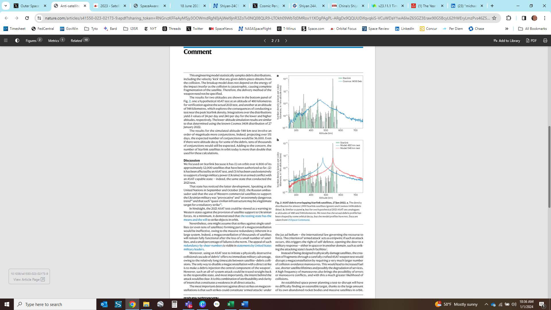
28 Dec: Nature Astronomy published a paper by Aaron Boley and Michael Byers, both from the University of British Columbia, which discusses the applicability of conducting a debris-generating kinetic Anti-Satellite Test to disrupt megaconstellation operations. Specifically, the authors modelled the affects of the Russian Cosmos-1408 DA-ASAT test if it had been conducted at the primary operating altitude of SpaceX’s Starlink (550km). Read Full Article.
– Russia hit Cosmos 1408 with a ground-based missile at 480km and produced 1,500 pieces of trackable debris that threatened the International Space Station (ISS) and China’s Tiangong space station.
– Direct-ascent ASAT tests use a missile launched from the ground, sea or air to destroy a satellite or rocket body owned by the testing state, using the tremendous kinetic energy of the collision.
– The debris from the 2021 test created complications for satellites at higher altitudes, including SpaceX’s Starlink ‘megaconstellation’. According to SpaceX, over 1,700 of the 6,873 collision-avoidance maneuvers performed by its satellites in the six months from 1 December 2021 to 31 May 2022 were due to Cosmos 1408 debris.
– This outcome raises the possibility that a state may conduct a ‘test’ with the intent of disrupting the space operations of another state.
– For Starlink, SpaceX reports using a collision probability threshold of 1 in 100,000 for conducting collision-avoidance maneuvers.
– If the 2021 target satellite had been closer to the Starlink 550km shell, instead of one at an altitude of 480km…the authors estimate
Starlink maneuvers would increase from 24/day to 240/day…an order-of-magnitude more conjunctions. Projecting over 151 days, the expected number of conjunctions would be 36,000.
Instead of being designed to physically damage satellites, the creation of fragments through a carefully crafted ASAT weapon test would disrupt a megaconstellation by requiring a very much larger number of collision-avoidance maneuvers. This would lead to increased fuel use, shorter satellite lifetimes and possibly the degradation of services. A high frequency of maneuvers also brings the possibility of errors or maneuver conflicts, and with this a much greater likelihood of collisions.
Spaceflight charts, launch-site updates, GPS interference maps and astronomy imagery featured in Issue 88.




Flash Insider
Subscribe to unlock full access to this Issue and the complete Flash archive.
Subscribe Now Already Subscribed? Log In