


20 Jun 2023: China launched the Shiyan-25 experimental satellite on an LM-6 from Taiyuan. Official sources noted only that Shiyan-25 entered the desired orbit and will satellite will mainly be used to carry out new Earth-observation technology experiments. Launch Video . - Shiyan-25 is currently in a 307 x 321 km x…
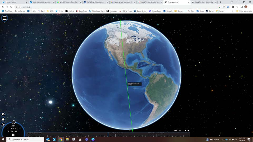
20 Jun 2023: China launched the Shiyan-25 experimental satellite on an LM-6 from Taiyuan. Official sources noted only that Shiyan-25 entered the desired orbit and will satellite will mainly be used to carry out new Earth-observation technology experiments. Launch Video.
– Shiyan-25 is currently in a 307 x 321 km x 96.6 deg sun-synchronous orbit with 10:30 local time orbital plane.
-Other than being an Earth imaging satellite, there is little additional information available.
-Shiyan-25 has the lowest altitude of any Shiyan satellite. The nearest orbit is Shiyan-11 at 476.6×463.8.
-Shiyan-25’s orbit is also the lower than any of the Yaogan satellites, the nearest being Yaogan-6 at 470x439kms.
-Shiyan-25 is even orbiting lower than any of the Gaofen satellites, the nearest being Gaofen-14 at 486.7x 484.2kms. This includes all of the Jilin imagery satellites, all of which are in orbits greater than 519kms.
-The only Chinese active satellites operating at lower orbits than Shiyan 25 are: 1) Longxia Yan 1 (2020, 266x253kms; 2) XJS C (2020, 267.4×254.7); and 3) Shaoniang Xing (2018, 308x305kms).
-Shiyan-25 is operating just beyond Very Low Earth Orbit (VLEO). VLEO satellites orbit at altitudes of between 150 to 300 kilometers, much lower than most satellites. These lower altitudes require propulsion to counter the relatively rapid orbital decay, due to much higher atmospheric drag. But they offer cost and performance incentives in the form of reduced power needs for data transmission, lower-latency data transfer, lower solar power-generation requirements, and higher resolution observation.
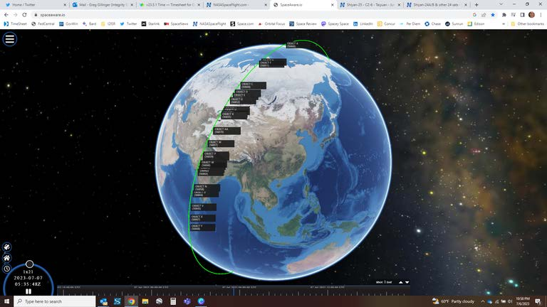
6 Jul 2023: Shiyan-24A/B spacecraft have not yet been specifically identified, however they and the 24 other payloads launched on a Lijian-1 on 7 Jun 2023, are being tracked. All objects are in a 507-512x484-492km Sun synchronous orbit. China has not released any additional information regarding their mission.
6 Jul 2023: Shiyan-24A/B spacecraft have not yet been specifically identified, however they and the 24 other payloads launched on a Lijian-1 on 7 Jun 2023, are being tracked. All objects are in a 507-512×484-492km Sun synchronous orbit. China has not released any additional information regarding their mission.
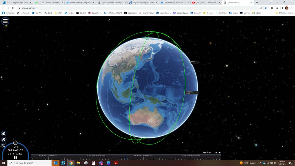
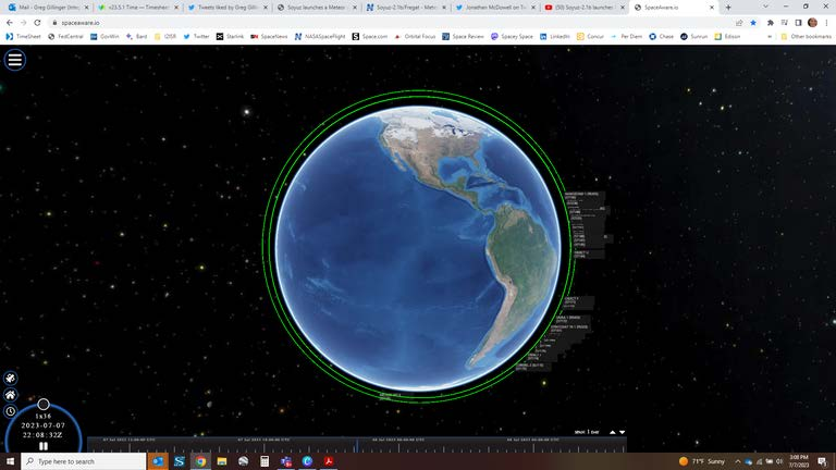
27 Jun 2023: Russia launched a Soyuz-2-1b rocket from the Vostochny spaceport , carrying the Meteor-M2-3 weather and climate-monitoring spacecraft, along with a cluster of 42 small satellites. Launch Video . -Meteor-M2-3 is the fifth spacecraft in the Meteor-M series introduced in 2009, including one lost in a launch…
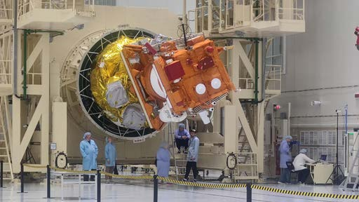
27 Jun 2023: Russia launched a Soyuz-2-1b rocket from the Vostochny spaceport, carrying the Meteor-M2-3 weather and climate-monitoring spacecraft, along with a cluster of 42 small satellites. Launch Video.
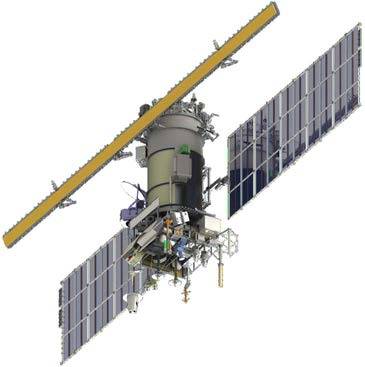
-Meteor-M2-3 is the fifth spacecraft in the Meteor-M series introduced in 2009, including one lost in a launch mishap in 2017.
– Meteor-M No. 2-3 satellite is in an 809 x 816 km x 98.8 deg orbit. The 42 small sats on the launch deployed into a lower ~570 km orbit.
– The ~3-ton satellite is designed to watch global weather, the ozone layer, the ocean surface temperature and ice conditions to facilitate shipping in the polar regions of our planet. Analysts suspect it also has a military use.
– Meteor-M2-3 differs from its predecessors by the presence of a deployable phased-array radar antenna for all-weather Earth scanning. First time payloads are a short-wave reflected radiation monitor, and a radio-frequency mass spectrometer for heliophysical studies of solar radiation.
– The launch of Meteor-M2-4 was promised before the end of the year. At the same time, Meteor M2-5 and Meteor M2-6 are in production at VNIIEM.
-Moscow-based Innovations Support Fund sponsored the launch of 16 university satellites in the CubeSat format, under the Space-Ï€ (Space-Pi) project. Roskosmos itself funded nine educational satellites under its UniverSat program, and identified a total of 17 other payloads as commercial.

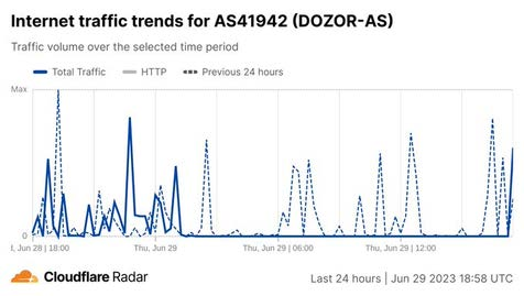
30 Jun 2023: Dozor-Teleport, a Russian satellite communications provider used by the country's Ministry of Defense and security services, was hit by hackers aligned with private military corporation (PMC), Wagner. On 3 July Dozor confirmed that hackers breached its systems. According to preliminary data, "the…
30 Jun 2023: Dozor-Teleport, a Russian satellite communications provider used by the country’s Ministry of Defense and security services, was hit by hackers aligned with private military corporation (PMC), Wagner. On 3 July Dozor confirmed that hackers breached its systems. According to preliminary data, “the infrastructure on the side of the cloud provider was compromised.” Watch video.
– Attackers targeted the satellite communication provider’s infrastructure, damaging user terminals. According to a pro-Ukrainian hacker and malware historian Herm1t, attackers could’ve severely damaged client equipment and the network core.
-Attacking a satellite provider’s ground based infrastructure is reminiscent of the Viasat attack which occurred just prior to Russia’s invasion of Ukraine in February 2022.
-Experts attributed the Viasat hack to Russia’s military intelligence arm, the GRU. But Wagner mercenaries could have worked closely enough with the GRU to have picked up techniques used in that attack. If so, it would have been easier for them to turn around and use these methods against Russia’s Dozor.
– According to the Internet Outage Detection and Analysis (IODA) project, the Dozor
network was down for 14 hours from 02:00 AM UTC to approximately 4 PM UTC on June 29.
– Dozor is part of Amtel Group, partly owned by Rosatom, Russia’s state nuclear energy corporation. All Amtel companies use the cloud provider Selectel, which was breached by
hackers targeting Dozor.
– Dozor-Teleport is used by Russia’s Ministry of Defense, ships of the Northern Fleet, the Federal Security Service (FSB), Rosatom, and other organizations. The network is also used by users in remote areas, such as tankers of Russia’s energy companies like Gazprom.
– The attackers portray themselves as associated with Yevgeny Prigozhin-led PMC Wagner, which recently attempted a march on Moscow. Earlier in the week, researchers discovered a ransomware strain called Wagner, that infects user devices and invites them to join the PMC Wagner.
– Additionally the attack defaced several Russian websites, publishing a message from the PMC Wagner claiming responsibility for the attacks. However, the Telegram page of the supposed attackers is not the same one used by PMC Wagner.
The attack would not be the first time hackers targeted Russian satellite networks. Last year, pro-Ukrainian hackers said they penetrated Gonets, a Russian low Earth orbit (LEO) satellite communications network, deleting a database crucial to its functioning.
Meanwhile, a group of hackers affiliated with Anonymous, NB65, said they disrupted Russia’s vehicle monitoring system by targeting Roscosmos, the Russian space agency.

6 Jul 2023: Hawkeye360 received a contract of undisclosed value from Australia's Department of Foreign Affairs and Trade for a pilot program in support of the Pacific Islands Forum Fisheries Agency. HawkEye 360 uses radio-frequency data analytics to geolocate electronic emissions and draw insights. Watch Hawkeye360…
6 Jul 2023: Hawkeye360 received a contract of undisclosed value from Australia’s Department of Foreign Affairs and Trade for a pilot program in support of the Pacific Islands Forum Fisheries Agency. HawkEye 360 uses radio-frequency data analytics to geolocate electronic emissions and draw insights. Watch Hawkeye360 capabilities videos. Part 1 (4:52) and Part 2 (5:45)
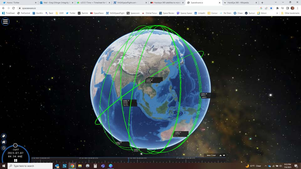
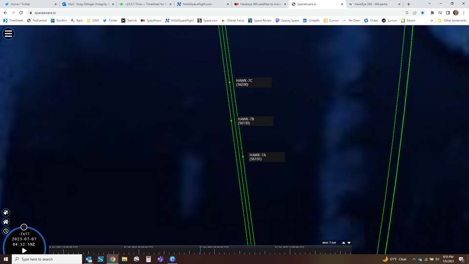
– Hawkeye360 (HE360) operates a constellation of 21 satellites that detect, characterize and geolocate radio frequency signals from emitters used for communication, navigation and security.
– HE360 satellites fly in triangular formations in low Earth orbit. As a cluster passes over an area, each satellite observes signal waveforms and downlinks the data to a cloud system on the ground where it’s analyzed.
-The contract tasks HE360 to provide satellite RF maritime analytics and training through 2023.
-The Pacific Islands Forum Fisheries Agency and its members will get data, analytics services and training support to identify illicit maritime activity within their waters.
– By analyzing RF data, HE360 can track maritime activity not detectable by Automatic Identification Systems (AIS).
– HE360 intends to launch 2 additional 3 satellite clusters in 2023, with one additional launch in 2024 to complete the 30 spacecraft constellation.
– Over the course of 2023 and 2024, Rocket Lab will deliver 15 satellites (five clusters) to low Earth orbit across three Electron missions.
– The first of the three missions launched successfully on January 24, 2023. Video.
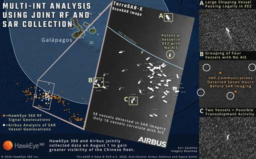
-In 2020 HE360 teamed with Airbus, which provided SAR imagery, to identify hundreds of illegal Chinese fishing vessels operating off the coast of the Galapagos Islands. By fusing multiple forms of intelligence, analysts found many dark vessels, and a better understanding of fleet activity.

26 Jun 2023: A new paper from the Mitchell Institute argues for the urgent need for the USSF to develop a broad range of offensive and defensive counterspace weapons. These weapons should be based on orbit, and are necessary to counter China. The paper also notes the need for a clear policy statement of US government…
26 Jun 2023: A new paper from the Mitchell Institute argues for the urgent need for the USSF to develop a broad range of offensive and defensive counterspace weapons. These weapons should be based on orbit, and are necessary to counter China. The paper also notes the need for a clear policy statement of US government intent, and the development of an integrated plan for building such an arsenal. Watch Interview with Maj Gen Miller.
– The paper, “Building US Space Force Counterspace Capabilities: An Imperative for America’s Defense,” acknowledges the value of diplomacy for norm setting and the service’s current focus on building resilience, but it says that these to approaches are not enough to provide deterrence to a more aggressive China and Russia – both of which have been steadily working to build up their own capabilities to target US satellites.
– The paper stresses that China is rapidly expanding its own military space capabilities – such as intelligence, surveillance and reconnaissance and communications satellites – designed to allow the People’s Liberation Army to better project force outside of its own territory, and its ability to go toe-to-toe with the US military in a conflict. Further, it posits the Space Force also needs offensive weapons, to take away advantages the PLA will gain from such new capabilities that put US forces in harms way.
-The recommendations in essence put forward an implementation plan for the “competitive endurance” framework, for achieving “space superiority” laid out by Chief of Space Operations Gen. Chance Saltzman in March. That strategy calls for the Space Force to develop capabilities to target adversary space systems in a manner that doesn’t result in a “Pyrrhic victory” by also destroying the space environment – what Saltzman dubbed as “responsible counterspace campaigning.”
-The paper adds the architecture should not just include ground, air, sea and space-based counterspace weapons to target Chinese space systems, but also US military satellites with on-board defense systems. It also requires a robust infrastructure – such as improved space domain awareness and satellite control networks – to allow operations to be executed “at scale.”
3 Jul 2023: Chang Guang (CGST), a Chinese satellite operator of the Jilin Earth Observation constellation, successfully achieved 10 Gbps satellite-to-ground laser communication via a Jilin-1 satellite. The downlink speed surpassed a previous record of 1 Gbps via radio frequency connectivity. The first laser…
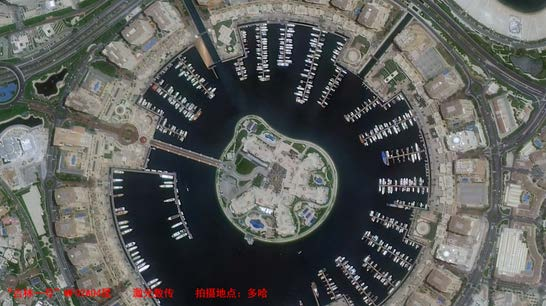
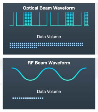
3 Jul 2023: Chang Guang (CGST), a Chinese satellite operator of the Jilin Earth Observation constellation, successfully achieved 10 Gbps satellite-to-ground laser communication via a Jilin-1 satellite. The downlink speed surpassed a previous record of 1 Gbps via radio frequency connectivity. The first laser demonstration downlink included a satellite picture of Doha, Qatar.
– CGST carried out the test with its Jilin-1 MF02A04 remote sensing satellite. The test was conducted in cooperation with the Aerospace Information Research Institute (AIR) of the Chinese Academy of Sciences (CAS).
-Chen Shanbo, chief designer of Jilin-1 MF02A04, said in a statement that the test was the first ultra-high-speed (10Gbps) for commercial applications in China, and signals numerous breakthroughs in key technologies.
-Jilin-1 MF02A04 was launched on 15 January 2023 with 13 other satellites including MF02A03 and MF02A07.
-The breakthrough could enable China to increase its transmission rates as the number of planned low Earth orbit constellations grows. With the additional use of inter-satellite laser links, this could help China overcome some of the challenges of a relatively lower level of global ground station infrastructure.
-The success of China’s recent space-to-ground laser communication experiment has set the stage for the subsequent large-scale application of 40 Gbps satellite-to-ground laser communication payloads.
-In addition to faster data transmission rates, lasers provide additional security, owing to their strong anti-electromagnetic interference capabilities.

23 Jun 2023: As part of a visit from Prime Minister Modi, India and the US have agreed to work more closely together in spaceflight, with India signing the Artemis Accords and the two countries planning an eventual joint mission to the International Space Station. See White House FACT SHEET . - In a joint press…
23 Jun 2023: As part of a visit from Prime Minister Modi, India and the US have agreed to work more closely together in spaceflight, with India signing the Artemis Accords and the two countries planning an eventual joint mission to the International Space Station. See White House FACT SHEET.
– In a joint press conference India announced it would become the 27th nation to sign the Artemis Accords. Prime Minister Modi stated “By taking the decision to join the Artemis Accords, we have taken a big leap forward in our space cooperation…In fact, in short, for India and America partnership, even the sky is not the limit.”
– The governments agreed NASA and the Indian space agency ISRO would develop “a strategic framework for human spaceflight cooperation” by the end of the year. Earlier this year, NASA had agreed to provide “advanced training” for an Indian astronaut at Houston’s Johnson Space Center.
-India has an existing program of lunar and Martian exploration, including Chandrayaan-3, scheduled to launch in July 2023 as the country’s second lunar lander.
Â
“By joining Artemis, India will be catapulted to the forefront of human space exploration, enjoying the benefits of the technologies and capabilities that will be developed through this singular journey of discovery…Conversely, the Artemis program will benefit greatly from the India’s extraordinary capacity to innovate and conduct ambitious activities in an affordable fashion.” — Mike Gold, former NASA official who spearheaded development of the Accords in 2020
29 Jun 2023: China delivered a set of satellites to Egypt as part of a program to develop Egypt's capacity to assemble, integrate and test satellites. -China delivered two satellite prototypes and one flight model to Egypt in March. The Egyptian Space Agency then carried out final assembly and testing at their…
29 Jun 2023: China delivered a set of satellites to Egypt as part of a program to develop Egypt’s capacity to assemble, integrate and test satellites.
-China delivered two satellite prototypes and one flight model to Egypt in March. The Egyptian Space Agency then carried out final assembly and testing at their Satellite Assembly, Integration and Test Center (AITC).
-The MisrSat II Satellite project began in 2019 when Beijing and Cairo signed a $72M grant for Egypt’s space program. It was the third grant provided by China to Egypt for a satellite project. Both countries initially signed a grant of $23M in 2016, and a second grant worth $45M in 2018.
– Earlier in 2023, China carried out a pair of launches placing Horus-1 and -2 satellites in orbit for Egypt. Those satellites were designed and built by China.
-In contrast, MisrSat II transfers technology and know-how to Egypt.
-The MisrSat II flight model will be transported to China for launch in the second half of this year. The imagery payload is expected to have a resolution of around two meters.
Â
“The linkage of this Misr II satellite project to the Belt and Road Initiative can be seen as a direct indicator that the Government of China sees space and satellite technology as part of the suite of offerings it is able to bring to bear in building relationships in Africa…In this regard, the project can be seen as part of broader competition for partnership and access to developing markets on the African continent.” — Ian Christensen, director of private sector programs at Secure World Foundation

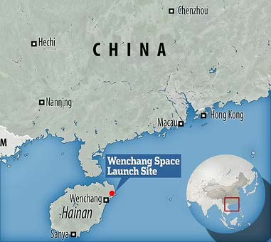
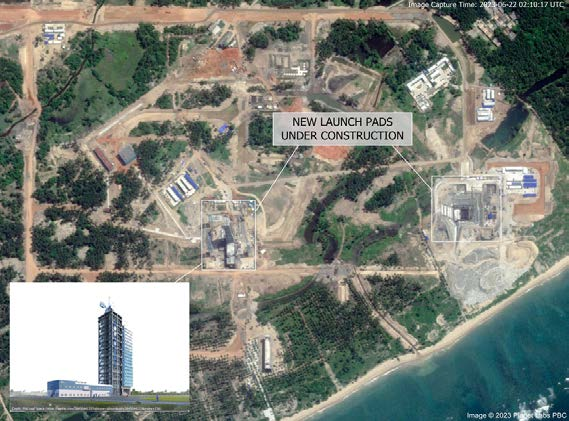
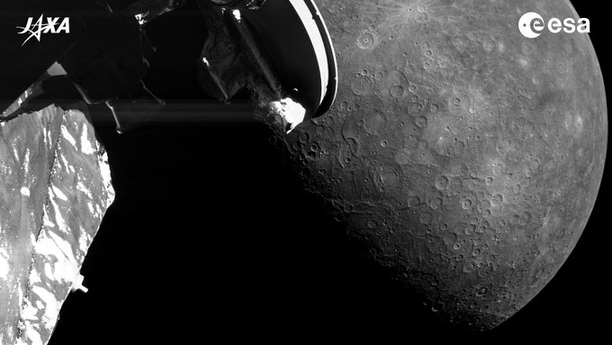
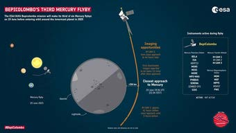
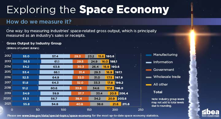
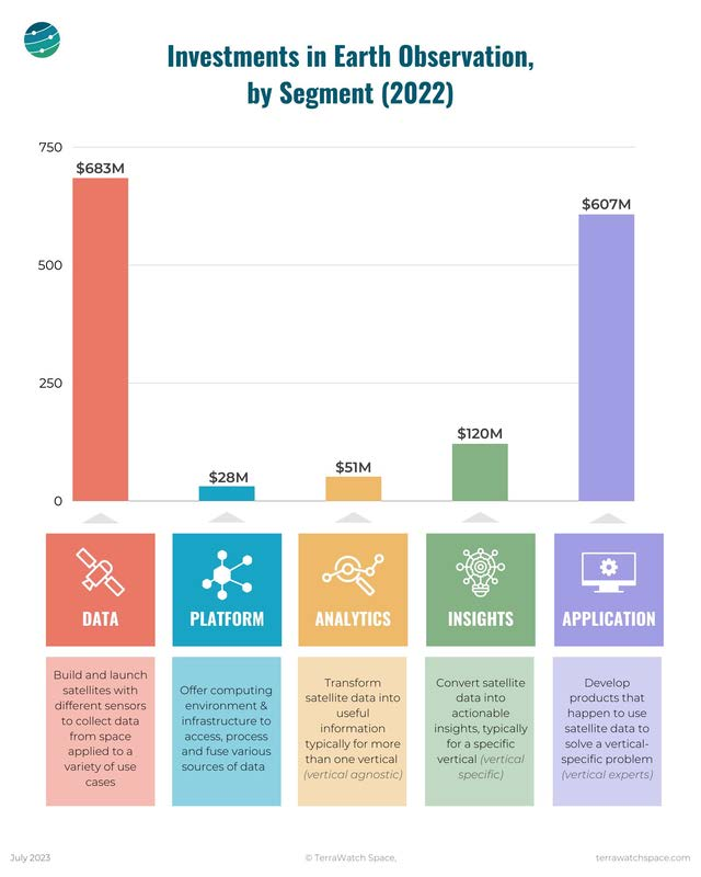
Images and graphics from the space domain, including Wenchang construction, BepiColombo, space-economy data, JWST ringed planets, and recovered North Korean rocket hardware.




Flash Insider
Subscribe to unlock full access to this Issue and the complete Flash archive.
Subscribe Now Already Subscribed? Log In